Showing posts with label bike integration. Show all posts

Friday, November 19, 2010

The Joy of Biking DC

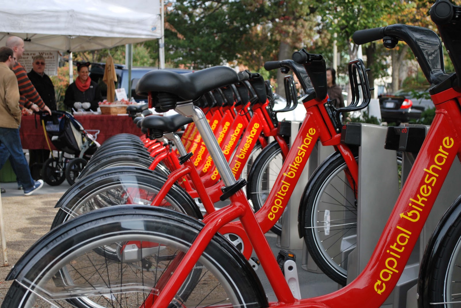
Bike share station in DC's Eastern Market
I spent much of my Halloween weekend in DC on a bike.  I was in DC to run the Marine Corps Marathon on Halloween, my first time ever attempting 26.2 miles, but on the days leading up to the race, I couldn't stop myself from punching it down those DC avenues on my rental, swerving from from one multi-lane avenue to another.  Pedaling around our capital city was an exhilarating experience.  Yes, my virgin marathon began with a little bit of telltale tightness in my hams, but it was worth it. (Yes...I finished the marathon.  The whole experience running MCM was thrilling...It certainly will not be my last 26.2!)
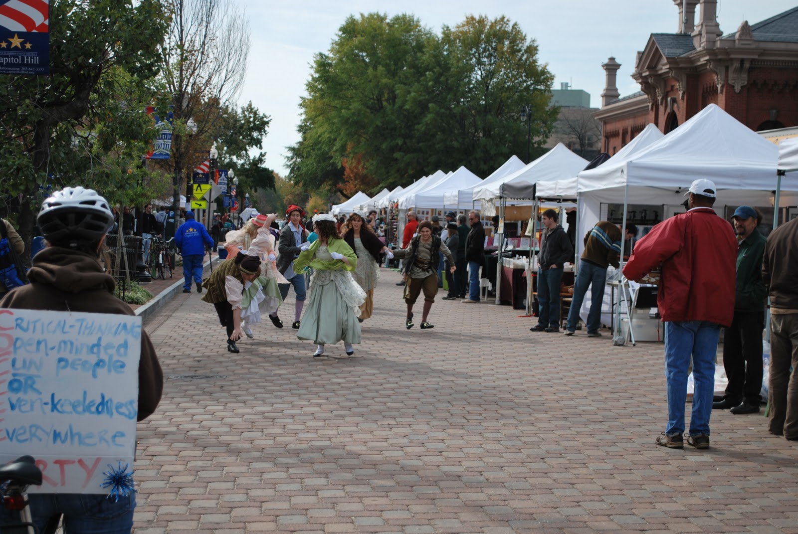
Surprisingly lucid thinking in DC

Short and sweet though my time was, I have now run and biked the District enough to become convinced that DC just might be the perfect city for both activities.  It is also the perfect city for rallying, which I did (along with the sign-bearer at right) that Saturday at Jon Stewart's Rally to Restore Sanity. That's an aspect of DC's virtues that requires travel of that more noumenal variety (the kind that tends to gum up Proper Scale enough), so I'll avoid it for now.

As for biking, never before have I traveled so happily down trafficky streets and avenues.  The thought dawned on me quite fast that this was not my typical urban biking experience.  I had to pause a moment to ponder about what made DC feel so different...

Pennsylvania Avenue
Was it the wide avenues?  Perhaps the generous amount of pavement everywhere in the District allows enough traffic slack to grant the cyclist some breaks to get in and out of traffic lanes easily, but (with the exception of Pennsylvania Ave. at left) you take your life into your own hands down many of these.  Let's put it this way, you need to be comfortable with clearances just inches between yourself and moving vehicles.  The thing that made a positive difference in my experience getting around on a bike in DC, as compared to my experience in Boston and Jerusalem, is hard to tag (in Charlotte, people, I don't even try). But this I noticed was something I appreciated about DC's Avenues: they run enough interference on faster traffic (due to congestion produced by plentiful merging points and intersections) to keep traffic at an even keel and closer to cycling speeds, while at the same time offering longer stretches of uninterrupted travel, which make both cyclists and drivers happy.  For cyclists, stops are just as annoying as for drivers in the grid; in fact, even more so, since having to stop at an intersection means breaking your hard-gained momentum, which is what allows you to stay at travel speeds matching the traffic alongside you.  Staying at these higher speeds allows you to safely share the road with vehicles, and, in fact, take command of a lane when necessary.  These kind of sharable arteries, with highly pedestrianized urban street fronts, are rare here in the States.  But DC is thick with them!  Because they are everywhere, traffic tends to be evenly distributed.  Even if they mess with your sense of orientation, these wide streets have a certain predictable pace, almost a kind of ordered, lolling behavior, that the cyclist picks up on intuitively and can use to his or her advantage. 

Approaching Eastern Market
Was there a difference also in the amenities?  That signature bikeway on Pennsylvania Avenue is a joy to ride down, certainly.  Some of the world-class city offerings, including the Capital Bikeshare program, were there, and I am sure these do much to encourage bike travel in DC. The bikeway network, on the other hand, was the limited-run variety rather than the comprehensive kind.  But I noticed that the bike lanes that do exist are actually necessary and do go a long way to make a difference, especially when they are actually needed to create some clearance for the cyclist to bypass backed up traffic, therefore granting the bike mode a coveted edge (and also allowing the cyclist to stay off the sidewalks to bypass such conditions).  Some of these lanes, as in the busy narrow streets in the Eastern Market area, make very obvious why bike travel in DC has long gained the favored mode status for many locals.

While planners like me riding around DC might quibble that the bike lane network is patchwork at best, I would say that not all the conveniences and provisions for bike travel across greater distances in the city are really needed.  Sure, judged by mere infrastructural capacity, DC's travel split on the surface is still skewed heavily toward the automobile.  As the images on the blogosphere today betray, New York today and, certainly, Portland are doing somersaults over our capital on this score. But DC has a whole lot of other pluses and lessons for improving bike travel.  Some of these may even obviate the need for the white stripes and pavement dedications.

A very sane cyclist observes an outdoor performance of the Pirates of Penzance unfolding at Eastern Market

Of course, the key ingredient making DC special is L'Enfant's grid.  It is, to be brief, a difference of amenity inherent to city form. When it comes to biking, city form is the first thing bike-supportive planning should think carefully about. Too few of us spend time thinking about it, although we deal with it implicitly if not directly in design.  When you are working with the right fabric, maybe you don't need the Portlandian exuberance with bikeway infrastructure.  DC seems to teach that maybe these solutions should be implemented only when they are actually necessary.

After a couple weeks mulling over my experience, I have slowly come to the realization that, in fact, L'Enfant's grid just might be peerless in its advantages for integrating multi-modal transportation effectively in heavily traveled districts ("might be peerless" ....I'm not yet ready to claim it outright, though I'm tempted).  The advantages that make bike travel special in DC are also the same advantages that make travel of all other modes there effective.  L'Enfant did DC a huge favor not only in giving the heart of DC wide, Parisian-style rights-of-way but in designing radial avenues that lace across DC's grid diagonally with respect to the rectilinear infill grid, giving DC plenty of what I call (as I've modified for my private odonomy on this blog) "Grand Avenues".   Grand Avenues help everyone.  They help motorists, cyclists, pedestrians, buses and even the underground subways with stations leading out to them (I'll explain why later).  Even when the pavement stops, Grand Avenues may still continue for pedestrians (such as across the rolling lawn of Capitol Hill for the pedestrians headed from the Eastern Market area to the Rally to Restore Sanity at right).  A city's Grand Avenues, it seems, get inside the heads of its citizens.  They seem to amplify the pulse and vitality of the city with what they connect.

Bike parking at our national public forum
DC, unlike every American city I know, splits traffic flow with avenues (instead of simply channelizing it to them).  It disperses and modulates traffic flows enough to make wide surface streets sharable between cyclists and vehicles.  All those skewed intersections simply multiply travel options.  In the cases where it doesn't, and the traffic is simply too thick and relentless to allow the cyclist the direct route option, the cyclist often has the option to navigate quieter local streets that circumvent the artery traffic. 

Previously, the precedents presented by places like Copenhagen and Portland led me to believe that the urban design challenge was to find ways to claim more pavement for the bike.  But DC seems to have taken the opposite tact, brazenly maximizing surface provisions for the automobile instead.  With all its rights-of-way, L'Enfant's city seems to have passed a sweet spot.  Instead of corralling and flagellating it, avenues here seem to placate traffic behavior, letting it switch often and lead more directly to its destinations. Sure, radial avenues intersecting at odd angles with the grid insert even more intersections than needed into it (maybe these serve a good purpose we're not appreciating?), and often these are the skewed kind of intersections that imagination challenged DOT's detest (and don't allow you to design, that's for sure!).  But, ...I rode a bike in DC, and I can't remember the last time I had as much fun on a bike...

Sunday, March 21, 2010

Welcome to the Next American Suburb

A New Model of Suburban Development? This photo demonstrates some smart neighborhood development features of note. Here are just some of the elements: (a) A greenway crossing in the foreground; (b) Bike lanes, but more importantly, roadway and neighborhood conditions that generate frequent bike trips; (c) Children (in the background crossing the street); (d) Townhomes (at right) populated by households that include said children and which suavely wrap around a super market and its parking lot; (e) In the background to the left is UNC Hospital's Wellness Center - basically a Y souped up with clinical services, therapy/rehab services and a rich array of preventative health-care and community supportive programs; (f) In the background, in the distance, is a retirement village center

I have recently come across an interesting community development that I believe is a compelling model for the next stage of "edge city" development. This is Meadowmont in Chapel Hill, N.C. I see in Meadowmont a transformational model that can re-mix and consolidate the separated uses of a typical suburb into a form whose smart-growth strategies effectively liberate Americans from that 7-day-a-week vehicular co-dependency that leads to sedentary lifestyles. This, and doing it in such a way that Meadowmont may actually represent a viable market model that has the thoughtful ingredients for successful replication. If LEED-ND has a version of Levittown (a development model that replicates), this might be it.

Among other things, Meadowmont offers yet another great example of what can be achieved with more tightly coordinated commercial, institutional and residential development - working in tandem with a cohesive, multi-modal neighborhood transportation strategy. As an urbanist, I have to be attuned to what is working in the market, and I think Meadowmont is an implemented precedent that offers great lessons to appreciate and chew on. I share here just a visual survey and some cursory comments. I think we can easily spot in Meadowmont (following in the trope of family-appealing New Urbanist developments such as Denver's Stapleton) some subtle but significant innovations to integrating a richer array of lifestyle services with neighborhood development, and which can create a market draw for them and can potentially entice capital markets to - not just embrace - but promote smart(er) growth. There are enough ideas here to warrant further contemplation, which I hope presage where development in the suburban periphery may be heading soon. (I must say... I would not mind it at all if Beazer, Centex and Pulte began to copy and paste some of the innovations Chapel Hill's signature development affords us.)

1) The interesting heart of the community is the UNC Wellness Center at Meadowmont, an impresive, greenway-hugging, environmentally friendly preventive health care and fitness center facility. If hospitals actually thought their job was to keep their clients healthy (not just treat their illnesses), they would probably create wellness centers right smack in the middle of their clients' communities.


2) Every generation shares a piece of the pie. The elderly are thoughtfully accommodated within closer proximity to the services of the community. The Cedars of Chapel Hill below is a continuing care facility facing a central, generous green and full-service community center. The Cedars are in close proximity from the town center and directly across the street from the Wellness Center above and the grocery store. An apartment complex buffers the retirement village from the busy arterial road.


2) The grocery store
(a Harris Teeter) is located centrally near the arterial and surrounded by townhomes. Where you would typically have a 20-40 foot commercial use setback filled with berms and water-needy plantings, you raise instead townhomes that eventually become populated with loyal customers who arrive and depart by foot and who no doubt visit you more frequently than other customers. Cha-ching.


3) Greenways
and multi-use trails connect all the dots. The central spine trail follows the main valley streams flowing through Meadowmont, the primary conveyances of storm water. This trail connects to crossing trails that offer crossing points across the stream, helping to tie the different parts of the neighborhood and its uses together. They actually offer a completely equivalent transportation facility (see below) which more directly connects uses to one another than the actual winding vehicular streets, meaning, walking and biking become more enticing options. Notice, by the way, that the backyards often open up to the greenway, giving the trail an intimate connection to the community. This means residents, especially children, have great access to the greenway and help keep it secure. (Contrary to logic hinged on parental paranoia, the presence of children is actually the very thing that helps keep an area safe and secure - if children are present, others use and enjoy the facility much better, and fear encounters with strangers less. More people on the trail then help keep the facility safer. It is a mutually reinforcing phenomenon.)


4) The neighborhood elementary school is located unobtrusively in the neighborhood, in a lower plain by the stream, well-below the tree line of the overlooking street. All the classrooms are directly connected to the outdoors via a colonnade which shades the outdoor learning spaces associated with each class room (like the arcade schools of the classical era). The school itself is generously daylit and is smartly comprised of three east-west oriented wings. But the most noteworthy thing about the school is that it can be accessed by the greenway trails connecting to the residential subdivisions surrounding it. I loved the covered bike parking facility (by the way, there is only one bike because I took the photo at 5 pm ...this bike is probably a teacher or staff-person's).


5) Luxurious townhomes ring the hill tops much like fortified Italian hill towns. Unfortunately, we see here some examples realizing current urban design fetish for employing greens-in-the-round, but at least the circular form here is suggested by hilltop topography ...unlike the useless usual. However much I sincerely doubt Jane Jacobs wanted us to invert the Panopticon, for all I know, these residents will want their "eyes on the park" in order to keep a careful watch over things.


6) These soccer moms can punt the minivan. This soccer field, I kid you not, does not have any vehicular access to it! Located across the stream from the elementary school, the only access afforded is via a bike path.


7) A head-turning mixed-use strategy represented by Meadowmont is the attempt to mix residential uses in an office building. Office uses represent a security liability, being depopulated at night, and thus typically require night-time security. The upper level of this office building helps to secure the building by allowing the upper (terraced) level to be used as luxury residential condominiums, granting it 24-hour use. This office building, along with the large detention basin it overlooks, also helps buffer the community from the arterial road. A bike path tunnel, crossing underneath the road, connects it to the office park across the road. I'm not sure how successful this residential-mix strategy is going to play out (the building is not rented out yet), but the sign advertising the potential uses definitely made me do a double-take.


8) But ...Meadowmont's strategic, multi-modal transportation integration is what really gets me excited about the future of suburban expectations in Chapel Hill. I note that planners have been insistent on providing an "equivalent facility" approach to bike-path integration (photo below left). Along the limited access arterials, that's where you put your wide bike thoroughfares on both sides of the road, and you create crossings wherever you can. This is the policy of Hilton Head Island as well. I welcome the raised expectations this will create for future development whole-heartedly. I also am warmed by the fact the office parks along Raleigh Road (the arterial I've been mentioning above) are circulated by compact, express buses at commuting times (photo below right ...taken between 6-7 pm).


...But of all the things I'm warmed the most about future of Meadowmont, and its potential long-lasting success as a model for greenfield development, is the fact that it has a good shot to be serviced directly by the TTA's future LRT, on the link connecting Chapel Hill to Durham. We all need to congratulate Chapel Hill planners for very conscientiously locating this TND, as Jarrett puts it, to be on the way. Between just the handful of smart growth principles mentioned above, think of how many vehicular trips Raleigh Road has been spared in the long-term.

Sunday, January 3, 2010

Alligator Urbanism

I'm back from my favorite town...Savannah, and new thoughts on odonomy abound (more later). I just spent a week surveying great developments in South Carolina and Georgia.


The development work I was most struck with were the interesting developments on the Marietta Street Corridor in Atlanta and DPZ-planned Habersham, near Beaufort, SC (all the photos here are of Habersham).

The biggest surprise of the trip was my first visit to Hilton Head Island, which I may blog more about later. Hilton Head showed me that a sustainable type of sprawl actually exists. Its really remarkable job integrating infrastructure for bike/ped transport was some of the most stellar I've ever seen. Of course, Hilton Head was built for bike use from its inception, and its relentlessly controlled planning represents a resort-style urbanism (or sustainable sprawlism?), the kind that is way out of the adoptable range and integrative capacity of most suburban communities. But the respect to the landscape was superb. Hilton Head's nearly unbroken sea pine canopy and high standards for vegetated screening are a work of amazement. You really do get the impression that alligators coexist happily with humans in that sprawl. I'm surprised as a planner that I haven't heard more about Hilton Head, especially as we are now increasingly confronted with the problem of sustainably "retrofitting" our suburbs.

Both Hilton Head and Habersham made me appreciate the potential of landscape design to make sprawl more sustainable...and a rich experience - the kind that appeals strongly to most Americans. Call it golf-cart urbanism if you like, but I really like it when golf-course tested landscape architects get involved in urban design. The results are very interesting, and I was quite surprised at the level of thought we can glean from these experts to carry over into our TOD's and urban developments.


So far, Habersham is the best TND sprawl I've seen (but...my...what beautiful and interesting sprawl!). While Habersham for sure appeals to the second home 55 and over crowd that populates these places around Hilton Head, evidence abounds that a fair amount of families with children live in the neighborhood.

If you are an urban designer, landscape architect or planner, a good vacation to consider is a trip to Savannah/Hilton Head. You are guaranteed at least three treats: Savannah's Historic District (with its unparalleled grid of insights - yes more odonomic contemplation is in order!), Hilton Head Island's tremendously cohesive and well-integrated bike paths (with a trail system featuring boardwalks through the swampy areas, BMP's and parks), and Habersham.

Habersham, in a way, represents a more urbanistic approach to do Hilton Head, and it employs road and landscape design at a level of subtlety that left me there for hours carefully observing the details. To me it represents the best imaginative work of DPZ I've seen so far. You can tell they really went out of their way to prove that design for 18 mph can be interesting - never "one size" and "one solution" and always respecting and purposefully integrating the existing trees and site conditions.

If you do go... Do NOT forget...Be sure to bring a bike!